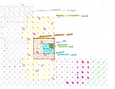
The last post gave a "color code" of small squares to represent a concept of the land use phenomena that had joined together my Jones surname ancestors. The smallest square colored "pink" represented the toft where the first generation [Gadforch JA-1] enclosed the land and, to "plant" the first seeds of the family tree. His son [Ynyr JB-1] continued the four-acre plot system, to the next son Tudor Trevor [JC-1], to Dingad [JC-1] who began the branch to my own Jones surname family tree. Generation after generation (see post June 3rd: "To Tell The Tale, Follow The Yellow Brick Road") from "shareland", to "holding" and, to "Townland" it continued. Now, just imagine when the generations grew to the "Maenol" (4 Townlands) and, to the "Commote" which joined 12 "Maenol"! The following figure continues the thought process to show how all this living might relate.
The "Townland" is outlined in orange and adjoining groups of "Townland" are shown in all sorts of colors trying to demonstrate the possible relationship to one another. The clusters fill the page with all sorts of little squares each representing a toft of 4 acres. Each "Townland" clusters about and, when 4 of these [256 acres each] expand, a "Maenol" (manor) [1023 acers] is organized with a mayor and others (post of April 10th). Now expanding the whole bunch of little squares to the whole page a "Commote" (12,288 acres!) is named. This "Commote" became the standard social and cultural unit of all the ancestors of the day. {ca. 800 A.D. to before the black death of 1350 A.D.}

No comments:
Post a Comment